Picture 1 of 2

Gallery
Picture 1 of 2


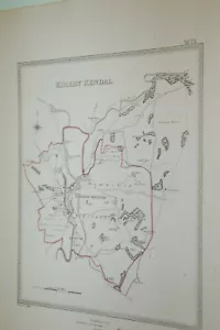
1835. KENDAL. MAP. TOWN PLAN. BY R CREIGHTON. GOOD CONDITION. WESTMORLAND
£7.83
or Best Offer
Condition:
“GOOD”
- Buy it now1835. KENDAL. MAP. TOWN PLAN. BY R CREIGHTON. GOOD CONDITION. WESTMORLAND
Oops! Looks like we're having trouble connecting to our server.
Refresh your browser window to try again.
Postage:
£9.00 Royal Mail International Standard.
Located in: SCOTLAND, United Kingdom
Delivery:
Estimated between Fri, 9 May and Thu, 22 May to 43230
Returns:
No returns accepted.
Payments:
Get more time to pay. See payment informationfor PayPal Credit - opens in a new window or tab
Shop with confidence
Seller assumes all responsibility for this listing.
eBay item number:405041299000
Item specifics
- Seller notes
- “GOOD”
- Antique
- Yes
- Date Range
- 1800-1899
- Type
- Topographical Map
- Format
- Sheet Map
- Printing Technique
- Copper Plate
- Year
- 1835
- Original/Reproduction
- Antique Original
- Country/Region
- England, United Kingdom
- County
- Cumberland, Cumbria, Westmorland
Item description from the seller
About this seller
countryhousedownsize
100% positive Feedback•4.2K items sold
Registered as a private sellerThereby, consumer rights stemming from EU consumer protection law do not apply. eBay buyer protection still applies to most purchases.
Seller Feedback (3,482)
- *****- Feedback left by buyer.Past 6 monthsVerified purchaseGreat item, as described and very well packed for postage. A great seller, will buy again.
- *****- Feedback left by buyer.Past 6 monthsVerified purchaseFramed print arrived, extremely well packaged, which was assuring to see, thank you. The framed print was exactly as the photo on the website. It also came with an A4 information page about the subject matter, which was very informative and I will keep this with the print for my children to read. (They may not always remember the history behind every print, painting or etching that I own) often nicer to have a paper provenance than just Google! ( : Gone to a Good Home, Will be looked after.
- *****- Feedback left by buyer.Past 6 monthsVerified purchaseThank you for this fascinating map. It's going to be a pleasure to refer to when mounted. Very quickly posted and very well packaged. Also thank you for the printed description. Excellent seller
This is a private listing and your identity will not be disclosed to anyone except the seller.
More to explore:
- Antique European Maps & Atlases Westmorland,
- Westmorland Antique Europe County Maps,
- Westmorland Antique Europe Atlas Maps,
- Westmorland County Map Antique Europe Sheet Maps,
- Westmorland County Map Antique Europe Atlas Maps,
- Westmorland Copper Plate Antique Europe Maps & Atlases,
- Antique European Maps & Atlases Westmorland 1600-1699 Date Range,
- Westmorland 1800-1899 Date Range Antique Europe Sheet Maps,
- Westmorland 1700-1799 Date Range Antique Europe County Maps,
- Antique African Maps & Atlases Cape Town