Picture 1 of 9


Gallery
Picture 1 of 9


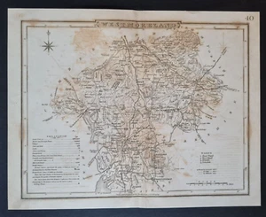
Antique (c. 1850) map - Westmorland / Westmoreland / Cumbria - Tallis -
£5.95
Condition:
- Buy it nowAntique (c. 1850) map - Westmorland / Westmoreland / Cumbria - Tallis -
Oops! Looks like we're having trouble connecting to our server.
Refresh your browser window to try again.
Postage:
Located in: Romford, United Kingdom
Delivery:
Varies
Returns:
30 days return. Buyer pays for return postage. If you use an eBay delivery label, it will be deducted from your refund amount.
Payments:
Get more time to pay. See payment informationfor PayPal Credit - opens in a new window or tab
Shop with confidence
Seller assumes all responsibility for this listing.
eBay item number:277007892997
Item specifics
- Antique
- Yes
- Date Range
- 1800-1899
- Type
- County Map
- Era
- 1800s
- Original/Reproduction
- Antique Original
- Cartographer/Publisher
- Tallis
- Country/Region
- England
- County
- Cumbria, Westmorland
Item description from the seller
Seller business information

Seller Feedback (568)
- e***9 (84)- Feedback left by buyer.Past 6 monthsVerified purchaseDelightful prints. Better than described. Carefully packaged and good value. Arrived in a timely manner too. Great seller communication. Thank you so much for a fabulous sale! Highly recommend the seller therefore.
- 2***5 (78)- Feedback left by buyer.Past 6 monthsVerified purchaseExactly as advertised and promptly delivered. It arrived well packaged and there was good communication. Extremely happy with my purchase and the service. Recommended seller +++++
- l***m (264)- Feedback left by buyer.Past monthVerified purchaseWell priced, good packaging and delivery - item as described. Recommend seller.
More to explore:
- Antique European Maps & Atlases Cumbria,
- Cumbria Antique Europe Folding Maps,
- Cumbria Antique Europe County Maps,
- Cumbria Antique Europe Sheet Maps,
- Antique European Maps & Atlases Westmorland,
- Westmorland Antique Europe County Maps,
- Cumbria Antique Europe Ordnance Survey Maps,
- Westmorland County Map Antique Europe Sheet Maps,
- Westmorland Copper Plate Antique Europe Maps & Atlases,
- Cumbria 1800-1899 Date Range Antique Europe County Maps
Seller Feedback (568)
- e***9 (84)- Feedback left by buyer.Past 6 monthsVerified purchaseDelightful prints. Better than described. Carefully packaged and good value. Arrived in a timely manner too. Great seller communication. Thank you so much for a fabulous sale! Highly recommend the seller therefore.
- 2***5 (78)- Feedback left by buyer.Past 6 monthsVerified purchaseExactly as advertised and promptly delivered. It arrived well packaged and there was good communication. Extremely happy with my purchase and the service. Recommended seller +++++
- l***m (264)- Feedback left by buyer.Past monthVerified purchaseWell priced, good packaging and delivery - item as described. Recommend seller.