Picture 1 of 3


Gallery
Picture 1 of 3


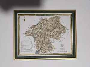
Antique Map Of Cumbria (Westmoreland) By E.W. Brayley from 1845
£16.10
or Best Offer
Condition:
- Buy it nowAntique Map Of Cumbria (Westmoreland) By E.W. Brayley from 1845
Oops! Looks like we're having trouble connecting to our server.
Refresh your browser window to try again.
Postage:
Located in: Leamington, United Kingdom
Delivery:
Varies
Returns:
No returns accepted.
Payments:
Get more time to pay. See payment informationfor PayPal Credit - opens in a new window or tab
Shop with confidence
Seller assumes all responsibility for this listing.
eBay item number:164562781231
Item specifics
- Year
- 1845
- County
- Cumbria
- Format
- Atlas Map
- Cartographer/Publisher
- EW Brayley
- Era
- 1800s
- Type
- County Map
- Antique
- Yes
- Original/Reproduction
- Antique Original
- Date Range
- 1800-1899
- Printing Technique
- Manuscript/Hand drawn
- City
- Kendal
- Country/Region
- United Kingdom
Item description from the seller
About this seller
tpg87
30 items sold
Registered as a private sellerThereby, consumer rights stemming from EU consumer protection law do not apply. eBay buyer protection still applies to most purchases.
Seller Feedback
No Feedback yet
More to explore:
- Antique European Maps & Atlases Cumbria,
- Cumbria Antique Europe Folding Maps,
- Cumbria Antique Europe County Maps,
- Cumbria Antique Europe Sheet Maps,
- Cumbria Antique Original Antique Europe Sheet Maps,
- Cumbria Antique Europe Ordnance Survey Maps,
- Antique European Maps & Atlases Cumbria 1800-1899 Date Range,
- Antique European Maps & Atlases Cumbria 1700-1799 Date Range,
- Antique Original Nautical Map Antique Sheet Maps,
- Antique Original County Map Antique Wall Maps