Picture 1 of 5


Gallery
Picture 1 of 5


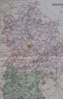
1895 Bedfordshire county map. Victorian print. Bedford, Luton, Dunstable.
£13.12
or Best Offer
Condition:
- Buy it now1895 Bedfordshire county map. Victorian print. Bedford, Luton, Dunstable.
Oops! Looks like we're having trouble connecting to our server.
Refresh your browser window to try again.
Postage:
£4.00 Royal Mail International Standard.
Located in: Swindon, United Kingdom
Delivery:
Estimated between Fri, 2 May and Thu, 15 May to 43230
Returns:
14 days return. Buyer pays for return postage. If you use an eBay delivery label, it will be deducted from your refund amount.
Payments:
Get more time to pay. See payment informationfor PayPal Credit - opens in a new window or tab
Shop with confidence
Seller assumes all responsibility for this listing.
eBay item number:156085253208
Item specifics
- Antique
- Yes
- Date Range
- 1800-1899
- Type
- County Map
- Printing Technique
- Lithography
- Format
- Atlas Map
- Year
- 1895
- Era
- 1800s
- Cartographer/Publisher
- F S Weller
- Original/Reproduction
- Antique Original
- City
- Bedford
- Country/Region
- England
- County
- Bedfordshire
Item description from the seller
Seller business information
About this seller

Swift Collectables Maps Prints
100% positive Feedback•2.0K items sold
Registered as a business seller
Seller Feedback (746)
- h***5 (49)- Feedback left by buyer.Past 6 monthsVerified purchaseAs described and good quality. Fast delivery and well packed. Top ebayer. Thanks.1904 Worcestershire & North Gloucestershire large antique map. For framing. (#155697106785)
- j***4 (40)- Feedback left by buyer.Past monthVerified purchaseItem matched photos and description. This was my first time receiving an item from the UK; I found the shipping time to be quick considering the distance traveled. Print is quite lovely! Very pleased.
- 2***m (63)- Feedback left by buyer.Past 6 monthsVerified purchaseThe print was as described, arrived as stated and well packaged, thank you.Beverley Minster. Antique East Yorkshire print 1908. Artist Gordon Home. (#155820812562)
More to explore:
- Bedfordshire Antique Europe County Maps,
- Bedfordshire Contemporary Antique Europe County Maps,
- Bedfordshire 1700-1799 Date Range Antique Europe County Maps,
- Bedfordshire 1600-1699 Date Range Antique Europe County Maps,
- Bedfordshire Antique Europe Atlas Maps,
- Bedfordshire Antique Europe Folding Maps,
- County Durham County Map Antique Europe Atlas Maps,
- Antique European Maps & Atlases Bedfordshire,
- Bedfordshire Ordnance Survey Map Antique Europe Sheet Maps,
- Northumberland Antique County Maps
Swift Collectables Maps Prints
100% positive Feedback•2.0K items sold
Registered as a business seller
Seller Feedback (746)
- h***5 (49)- Feedback left by buyer.Past 6 monthsVerified purchaseAs described and good quality. Fast delivery and well packed. Top ebayer. Thanks.1904 Worcestershire & North Gloucestershire large antique map. For framing. (#155697106785)
- j***4 (40)- Feedback left by buyer.Past monthVerified purchaseItem matched photos and description. This was my first time receiving an item from the UK; I found the shipping time to be quick considering the distance traveled. Print is quite lovely! Very pleased.
- 2***m (63)- Feedback left by buyer.Past 6 monthsVerified purchaseThe print was as described, arrived as stated and well packaged, thank you.Beverley Minster. Antique East Yorkshire print 1908. Artist Gordon Home. (#155820812562)